A Harbour Walk for Noticing the Edge Between Land and Water
A harbour walk reveals how paths, walls, steps and open views shape the shore, giving you a clearer way to read the meeting of land and water.
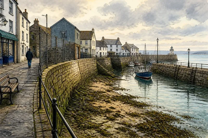
At low tide, a narrow strip of damp stone appears below the harbour wall, marked by seaweed and the faint lines of water that have just withdrawn. A harbour walk can make this changing edge easier to read: look not only towards the boats, but at how paths, walls, steps and gaps arrange the meeting of land and water.
Choose a public route that follows the shore, and move at a pace that leaves room to stop without blocking other people. The numbered observations below work as prompts rather than a prescribed circuit. If the harbour is busy, exposed or affected by changing tides, stay on signed paths and respect barriers; there is no need to approach the water’s edge to understand its shape.
1. Find the harbour’s landward line
Begin where the ordinary settlement gives way to working or open waterfront. The transition may be a change in paving, a low wall, a railing, a slipway or simply a view that opens between buildings. Notice where your route first gives you an uninterrupted look at the water, and what happens to the ground beneath your feet at that point.
This threshold often reveals who the route serves. A broad, even pavement may carry through from a town street, while a narrower path bends around a harbour structure. A public bench can signal a place to pause; a gate or working yard may mark a boundary that visitors should not cross. Read the route as a sequence of permissions and passages, not as an invitation to inspect every surface at close range.
Say you enter a harbour from a row of shops and find the pavement narrowing beside a fenced boatyard. You could stay on the public pavement and note how its view changes as it follows the fence; the expected result is a clearer sense of where the town’s everyday route meets the harbour’s working edge, without entering the yard.
2. Follow the path’s turns
Watch how the walking route behaves as the shoreline changes direction. It might keep a steady line behind a wall, dip towards a landing, or curve inland around a building. Each turn changes what is visible and how close a walker feels to the water. A straight path can make the harbour seem like a continuous frontage; a turning one may reveal it in shorter, more sheltered glimpses.
At a bend, pause on the landward side of the path and compare the view ahead with the one behind. Look for the element that prompted the turn: a wall, a building corner, a change in shore level or a route reserved for harbour work. The turn is useful evidence of how movement has been fitted around the coast, even when the structure itself is plain.
Do not try to follow every track that appears to lead closer to the water. Some routes end at private moorings or working areas, and an inviting gap is not necessarily a public entrance. The useful observation is the choice the main path makes, not how far you can wander beyond it.
3. Read the wall as a boundary
A harbour wall can hold back water, protect a walkway or separate public space from a working area. From the path, note its height and continuity, then see whether it has openings, railings or changes in level. These details affect the relationship between walker and shore: a solid wall may screen the water below, while a gap can frame a small view without making the shore directly accessible.
Look along the top edge as well as at the face. A coping stone may offer a narrow, level line above a rougher wall, while a railing lets the view pass through but sets a visible limit. Observe where the boundary meets a building or the path. A seam, offset or return can show that the walkway has been guided around an existing obstacle rather than laid as one uninterrupted strip.
Weather marks can help orient your view, but they do not tell a complete story on their own. Dark staining, salt deposits or attached seaweed may indicate regular contact with spray or water, while the conditions and maintenance of the harbour also shape what you see. Treat them as clues to the wall’s relation to its setting, not as a precise record of a tide or storm.
4. Notice the steps and landings
Where steps descend towards the shore, first look at their arrangement from the public path. Some lead to a landing used by boats; others meet a lower path, a slipway or a place that is submerged at certain tide states. The design communicates a change of level, but it does not by itself confirm that the route is open or safe to use.
Notice whether the steps run directly down from the street or turn alongside a wall. A direct descent makes the water feel close and reachable. A landing set back from the edge, or screened by a parapet, keeps a pause between the walker and the shore. Ramps and slipways offer another kind of transition: their long, sloping surfaces make the movement of boats and equipment more legible than a flight of steps does.
From a safe public position, compare the upper path with the lower landing. Is the transition visible from above, or concealed until the route turns? Does a railing continue downwards, or stop at a clearly marked boundary? These observations show how the harbour handles access and separation. Do not descend where access is unclear, where surfaces are wet or slippery, or where signs and barriers direct people away.
5. Look for the water’s working edge
Harbours bring boats, people and equipment close to the shore, so the waterline is often shaped by activity as much as by landform. From the public route, notice where boats can come alongside and where the edge is interrupted by mooring posts, ladders or a slipway. Ask how these features fit beside the walking route: is there a shared stretch, a visible division or a point where the public path pulls back?
Sound can add another layer without requiring closer access. A chain moving against a post, water tapping beneath a landing or footsteps changing on boards can help you notice where the edge is hard, hollow or sheltered. You do not need to identify every sound. Simply connect it to what is visible: an enclosed basin may mute the movement of water, while an exposed outer edge may make it more apparent.
Keep working space working. Avoid touching ropes, moving equipment or standing where people need to pass. A harbour is not a static display; a clear gap beside a bollard may be part of someone’s route rather than a place to pause. Watching from the public path can show how the waterfront functions without interrupting it.
6. Compare enclosed and open views
A harbour can alternate between close, framed views and broad openings. At one point, a wall or building may screen the horizon; farther along, a gap between structures may reveal open water. Notice what the route asks your eyes to do as those conditions change. Do you look along a wall, through an opening, across a basin or out towards the harbour entrance?
Compare the width of the view with the width of the path. A narrow passage beside a high boundary can make the water feel distant, even when it lies just beyond the wall. A broad apron beside an open basin may give the walker space to turn towards the shore. Neither arrangement is inherently better; each sets a different pace and degree of exposure.
The edge can also be partly hidden by moored boats, storage sheds or a bend in the harbour. Rather than treating the obstruction as a failed view, notice how the path handles it. Does it lead to another opening, or does the shoreline remain enclosed for a while? The sequence is part of the place’s character: settlement and harbour do not always meet in one uninterrupted panorama.
7. Notice what the route leaves out
Every harbour walk offers a selective view. A wall may conceal a low shore, a fence may separate visitors from boat storage, and a building may screen the water until the path passes its corner. Notice what remains unseen as carefully as what appears. This helps distinguish the public route from the full working landscape around it.
Look for places where the path deliberately pulls away from the water. That separation may make room for vehicles, equipment or private access, or simply follow a change in the land. The important point is not to guess the reason from appearance alone. Instead, register the effect: the water moves out of view, the route becomes quieter, or the settlement begins to face inland again.
At the end of the walk, look back once from a safe, public stopping place. The harbour’s edge may now read as a connected sequence: an entrance, a turn, a boundary, a landing and an opening towards wider water. If one section was hidden or inaccessible, leave it as an unanswered part of the route. Trying to find a viewpoint from an unsafe or restricted place adds little to the observation.
Questions about harbour walks?
What should I look for on a harbour walk?
Notice where the public path meets the water, how walls and railings divide spaces, and where steps or ramps change the level. Then compare enclosed views with open ones to see how the route shapes your sense of the shore.
How can I tell whether harbour steps are public?
Look for signs, gates, barriers and clear connections to the public path, but do not assume that steps are open simply because they are visible. If access is uncertain, remain on the signed route and observe the landing from there.
Does the tide change what a harbour walk reveals?
Yes: water may cover or uncover parts of the shore, and the visible line can shift around steps, walls and landings. You can notice those differences from a safe public route without approaching slippery surfaces or entering restricted areas.
What is worth recording after the walk?
Write down a few route changes rather than trying to describe every building or boat. A note such as “path turns inland behind a wall before the basin opens” preserves the relationship between movement and view.
Keep the route simple
A harbour walk does not need a special map or a long list of objects to notice. A phone note or pocket notebook is enough if you want to remember where a path turned or a view opened. It is not worth trying to photograph every wall, step and boat, or to chase a perfect view beyond the public route; that can pull attention away from the changing edge you came to observe.
Use the route itself as your guide. Follow the public path, pause where other people can pass, and let each change in level or visibility sharpen your attention. For a harbour walk, the most revealing moment may be a small one: the instant a solid boundary ends and the water becomes visible beside the town.